PulseAugur / Brief
EN
LIVE 01:08:45

Brief

last 24h
[4/4] 221 sources

Multi-source AI news clustered, deduplicated, and scored 0–100 across authority, cluster strength, headline signal, and time decay.

  1. Does GPS Help AI See Better? Testing Location Encoders for Satellite Imagery

    A new benchmark study explores how to best incorporate geographic location data into AI models for satellite image analysis. Researchers tested three methods—naive sin/cos, GeoCLIP, and SatCLIP—to encode latitude and longitude, finding that while naive sin/cos produced the most geographically coherent embeddings, SatCLIP offered a better balance for land-cover classification. The study used a DINOv2 vision model and the EuroSAT dataset to evaluate the effectiveness of these location encoders. AI
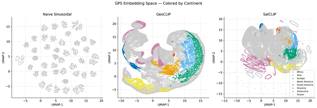
    Does GPS Help AI See Better? Testing Location Encoders for Satellite Imagery

    IMPACT Incorporating location data can significantly improve AI's ability to classify satellite imagery, moving beyond pixel analysis to understand geographic context.

  2. CryoNet: A Deep Learning Framework for Multi-Modal Debris-Covered Glacier Mapping. A Case Study of the Poiqu Basin, Central Himalaya

    Researchers have developed CryoNet, a deep learning framework designed to map debris-covered glaciers using a combination of multi-modal data. This framework integrates satellite imagery, topographic data, spectral indices, and radar information to distinguish between clean-ice glaciers, debris-covered glaciers, and glacial lakes. CryoNet achieved high performance metrics, including an overall IoU of 90.52%, outperforming existing state-of-the-art models in complex mountain environments. AI

    IMPACT This framework offers improved accuracy for mapping glaciers, crucial for understanding climate change impacts and freshwater resource management.

  3. OlmoEarth v1.1: A more efficient family of models

    Allen AI has released OlmoEarth v1.1, an updated family of models designed for processing satellite imagery more efficiently. These new models reduce compute costs by up to 3x for inference and require 1.7x fewer GPU hours for training, while maintaining performance on remote sensing tasks. The efficiency gains are achieved by optimizing the tokenization process for transformer-based architectures, specifically by merging resolution-based tokens without significant performance degradation. AI

    OlmoEarth v1.1: A more efficient family of models

    IMPACT Offers significant cost reductions for satellite imagery analysis, potentially enabling wider adoption of AI for environmental monitoring and mapping.

  4. SpectralEarth-FM: Bringing Hyperspectral Imagery into Multimodal Earth Observation Pretraining

    Researchers have developed SpectralEarth-FM, a new foundation model designed to process and fuse hyperspectral imagery with other Earth observation data like multispectral, radar, and temperature readings. This model utilizes a hierarchical transformer architecture that can handle varying spectral dimensions and integrates a cross-sensor fusion module. To train SpectralEarth-FM, a large dataset called SpectralEarth-MM was curated, containing over 40TB of co-located data from multiple satellite sensors, enabling state-of-the-art results on downstream tasks. AI

    SpectralEarth-FM: Bringing Hyperspectral Imagery into Multimodal Earth Observation Pretraining

    IMPACT Advances hyperspectral data processing and fusion, enabling more comprehensive Earth observation analysis.